Back Moika Afrikaans نهر مويكا ARZ Мойка Byelorussian Мойка BE-X-OLD Moyka (kanal) CEB Мойка (юханшыв) CV Mojka Danish Moika German Mojka Esperanto Río Moika Spanish
This article needs additional citations for verification. (November 2022) |
| Moyka | |
|---|---|
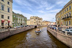
 View of the Moyka from the Pevchesky Bridge | |
| Native name | Мойка (Russian) |
| Location | |
| Country | Russia |
| Federal city | Saint Petersburg |
| Physical characteristics | |
| Source | Fontanka |
| • coordinates | 59°56′30″N 30°20′16″E / 59.94167°N 30.33778°E |
| Mouth | Neva |
• coordinates | 59°55′35″N 30°16′25″E / 59.92639°N 30.27361°E |
| Length | 4.67 km (2.90 mi) |
| Basin features | |
| River system | Neva basin |

The Moyka (Russian: Мо́йка /MOY-ka/, also latinised as Moika) is a short river in Saint Petersburg which splits from the Neva River. Along with the Neva, the Fontanka river, and canals including the Griboyedov and Kryukov, the Moyka encircles the central portion of the city, effectively making that area an island or a group of islands. The river derives its name from the Ingrian word Muya[1] for "slush" or "mire", having its original source in former swamp. It is 5 kilometres (3 mi) long and 40 metres (130 ft) wide.
The river flows from the Fontanka river, which is itself a distributary of the Neva, near the Summer Garden past the Field of Mars, crosses Nevsky Prospect and the Kryukov Canal before entering the Neva river. It is also connected with the Neva by the Swan Canal and the Winter Canal.
In 1711, Peter the Great ordered the consolidation of the banks of the river. After the Kryukov Canal linked it with the Fontanka River four years later, the river became so much cleaner that its name was changed from Muya to "Moyka", the latter from the Russian verb "to wash". With the spread of cars and services for them in post-Soviet Russia, the Russian word Мойка has become a common sight unconnected to the river as it very often means (car)wash, which may confuse foreign tourists.
In 1736, the first Moyka quay was constructed in wood. Four bridges originally spanned the river: the Blue, the Green, the Yellow, and the Red. The 99-metre (325 ft)-wide Blue Bridge, now hardly visible underneath Saint Isaac's Square, remains the widest bridge in the whole city.[citation needed]
Magnificent 18th-century edifices lining the Moyka quay include the Stroganov Palace, Razumovsky Palace, Yusupov Palace, New Holland Arch, Saint Michael's Castle, and the last accommodation and museum of Alexander Pushkin.[2]
- ^ "Мойка. Энциклопедия Санкт-Петербурга". Encyclopaedia of Saint Petersburg (in Russian). Retrieved 13 March 2021.
- ^ Isaeva, K., Aminova, D. (11 September 2019). "10 key places from St. Petersburg's literary map". Russia Beyond. Retrieved 6 February 2020.
{{cite web}}: CS1 maint: multiple names: authors list (link)
© MMXXIII Rich X Search. We shall prevail. All rights reserved. Rich X Search
